Table of Contents
What Are Amsterdam Maps and How Are They Commonly Used?
Amsterdam maps are visual guides that represent the layout of the city and its infrastructure.
They are commonly used to understand street patterns, district boundaries, transport connections, and the location of notable places.
Rather than referring to a single official map, the term “Amsterdam maps” generally covers a wide range of city layouts, transport diagrams, area-specific plans, and visitor-focused guides produced by different sources.
These maps are typically consulted for orientation, planning, and general reference rather than precise navigation alone.
This guide outlines the most common types of Amsterdam maps people look for and explains how each is generally used.
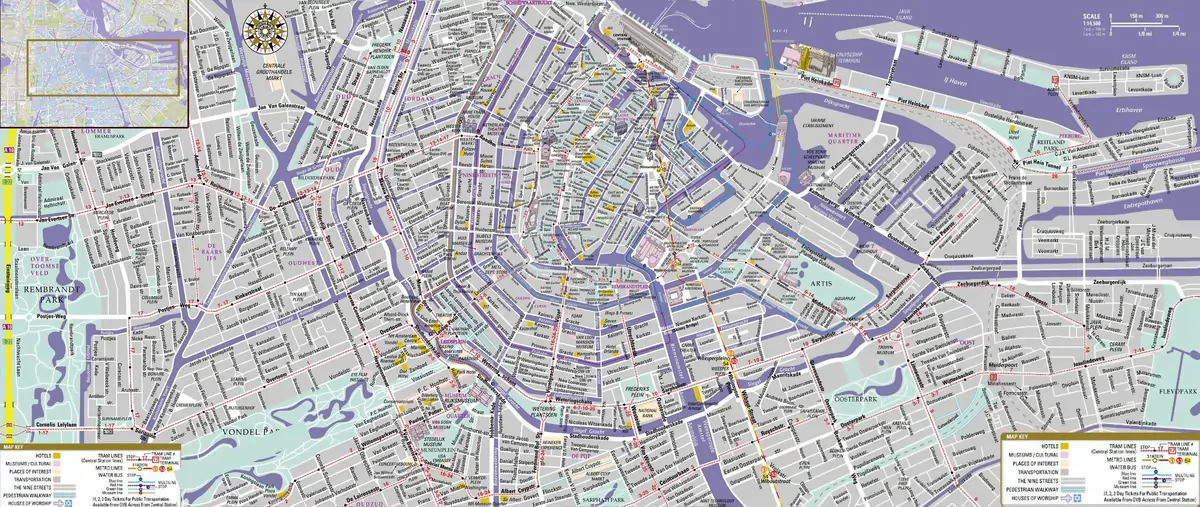
What Is an Amsterdam City Map?
An Amsterdam city map usually presents an overview of the entire city. It typically shows major districts, waterways, primary roads, and well-known locations.
City maps are often used to understand how different neighbourhoods relate to one another and to gain a broad sense of scale and layout before focusing on specific areas.
Such maps may be available in printed form, as PDFs, or as interactive digital versions, depending on the source.

What Does an Amsterdam Centre Map Usually Cover?
An Amsterdam centre map focuses on the historic and commercial core of the city.
It generally includes central streets, canal rings, squares, and frequently visited locations.
These maps are commonly used by visitors staying in or around the city centre, where street density and canal layouts can make orientation more complex without a focused overview.

What Information Is Typically Found on a Vondelpark Map?
A Vondelpark map is designed to show the internal layout of the park. It usually marks paths, entrances, water features, and public facilities.
Visitors often rely on these maps to understand the park’s size, locate amenities, and plan walks or cycling routes within the park boundaries.

How Are Shopping Maps of Amsterdam Used?
Maps highlighting shopping areas in Amsterdam are generally created to show retail-focused streets and districts rather than individual stores.
These maps often group areas by shopping character, such as major retail streets, independent shopping zones, or market areas.
They are intended as orientation tools rather than exhaustive retail directories.
Availability and format vary depending on the publisher, and naming conventions are not standardised.

Download The Amsterdam Shopping Guide/Map
What Is Shown on Amsterdam Parking Zone Maps?
Parking zone maps illustrate how parking regulations are divided across the city.
They typically show zone boundaries and indicate where different parking rules apply.
These maps are widely used by drivers to understand where paid parking applies and how regulations differ by area.
Specific rules and rates are normally confirmed through official municipal sources.

Download Amsterdam Parking Zones Map
What Is the Purpose of Park and Ride Maps?
Park and Ride maps show the locations of designated parking facilities on the outskirts of Amsterdam that are connected to public transport.
These maps are used to identify where drivers can leave their vehicles before continuing into the city by train, tram, metro, or bus.
Details such as pricing and conditions may vary and are usually subject to change.

What Do Schiphol Airport Departure Maps Show?
Maps for Schiphol Airport departures generally illustrate terminal layouts, departure halls, gate areas, and passenger services.
They are used by departing passengers to understand terminal structure and locate key areas such as check-in zones, security access points, and departure gates.

Download Schiphol Airport Departures Map
What Is Included on Schiphol Airport Arrival Maps?
Arrival maps at Schiphol Airport typically focus on baggage claim areas, customs exits, arrival halls, and onward transport connections.
These maps are commonly used by arriving passengers and those meeting them to understand where arrival processes take place and how to exit the airport efficiently.

Download Schiphol Airport Arrivals Map
How Do Amsterdam Rail Maps Support Public Transport Use?
Amsterdam rail maps show the structure of train, metro, and tram networks across the city and the surrounding region.
They are designed to clarify route connections and station locations rather than street-level detail, making them useful for understanding how public transport lines intersect and where transfers occur.

How Should Amsterdam Maps Be Used in Practice?
No single map covers every need. City maps provide context, area maps support local orientation, and transport or parking maps address specific logistical questions.
Using the appropriate type of map for each situation improves clarity and reduces confusion, particularly in a city with layered transport systems and dense urban planning like Amsterdam.
How Does Amsterdam’s Mapping History Connect to the Blaeu Mapmakers?
Amsterdam’s long association with mapmaking did not begin with modern city plans or transport diagrams.
During the seventeenth century, the city was one of Europe’s most important centres of cartography, producing maps that shaped how the world was understood and documented.
One of the most influential contributors to this history was the Blaeu family, whose Amsterdam-based publishing house produced some of the most detailed and widely used maps of the early modern period.
Their work reflects how Amsterdam developed both the technical skill and commercial infrastructure required to distribute maps on a global scale.
For readers interested in how historical mapmaking helped establish Amsterdam’s reputation as a centre of geographic knowledge.
The story of the Blaeu Firm Mapmakers provides valuable context beyond modern navigation tools.